Don's Hiking Log.......
Here are pictures from Don's hikes (he regularly hikes with Suzanne; he has also hiked with others: Anni, BobF, Dick, Jerry, Joe, Lyne, MikeC, MikeP, Oddvar and Tod, and occasionally with members of his family, Audrey, Cheri, Cory, John, Justin, Shane and Calle).
Links below to pictures for the hikes are ordered by region of Arizona, except for AZ Trail hikes, and color coded by year: 2006 & 2007, 2008, 2009, 2010, 2011, 2012, 2013, 2014, 2015, 2016, 2017, 2018, 2019
Quick Access to the latest hike click here; next to the latest hike click here.
Aravaipa Canyon Wilderness
Aravaipa Canyon Wilderness (11/6/2007 with Jerry)
Aravaipa Canyon Wilderness (4/28/2009 with Lyne, Suzanne & Dick)
Aravaipa Canyon Wilderness (5/1/2012; Don, Lyne & Suzanne; 15 miles through hike)
Arizona Trail (We are doing passages and sections of passages doable by day hikes
Passage 1 Huachuca Mountains
Passage 1 North From US83/FR48 to FRs 4757 & 228 (May 24, 2016; Don & Suzanne; 6.7 miles loop back through Sunnyside ghost town and cemetery)
Passage 1 FRs 4757 & 228 South 4 miles (May 31, 2016; Don & Suzanne, 8 miles RT in-and-out hike to Copper Glance Mine)
Passage 1 Montezuma's Pass to Border (Apr 12, 2016; Don & Suzanne; 4 miles RT in-and-out)
Passage 2 Canelo Hills East
Passage 2 Canelo Hills East - North Trailhead -West End (Mar 22, 2016; Don & Suzanne; 8.2 miles RT in-and-out)
Passage 2 Canelo Hills East - Exploring Access w/some hiking (May 25, 2015; Don & Suzanne; 3 miles RT walking and lots of driving on FR 4892)
Passage 2 Canelo Hills East - Midsection (Dec 22, 2015; Don & Suzzane; 5+ miles walking in-and-out; lots of driving on FR4892)
Passage 2 Canelo Hills East - South Trailhead - East End - Parker Canyon Lake West (Mar 15, 2016; Don & Suzanne, 8 miles RT in-and-out)
Passage 3 Canelo Hills West
Passage 3 Canelo Hills West (East 4 Miles) (Dec 2, 2014; Don & Suzanne; 8 miles RT for In-and-Out Hike)
Passage 3 Canelo Hills West (Middle 5 miles) (Dec 16, 2014; Don & Suzanne; 11 miles RT for In-and-Out Hike)
Passage 3 Canelo Hills West (South 5 miles) (February 17, 2015; Don & Suzanne; 9.8 miles RT for In-and-Out Hike)
Passage 4 Temporal Gulch (May 6 and April 22, 2014; Don & Suzanne; 22.5 miles total 12.5 miles of driving & 6 miles of hiking, oneway)
Passage 5 Santa Rita Mountains (April 7, 18 & 11, 2014; Don & Suzanne; 22 miles total in 3 dayhikes & 6 miles of driving)
Passage 6 Las Colinas (Jan 21, Feb 4, Mar 4 & 11, 2014; Don & Suzanne; 26 miles total in 4 dayhikes)
Passage 7 Las Cienegas (Jan 14 and Feb 11, 2014; Don & Suzanne; 10 mi hiking & 13 mi mountain biking)
Passage 8 Rincon Valley
Passage 8 North End (Jan 13,2015; Don & Suzanne; 7 mi RT for In-and-Out Hike)
Passage 8 Pistol Hill Road to X9 Ranch Road (Jan 20, 2015; Don & Suzanne; 5 mi RT for In-and-Out Hike)
Passage 8 Pistol Hill Road to South of Colossal Cave Park (Jan 27, 2015; Don, Anni & Suzanne; 5.8 miles through hike)
Passage 8 Gabe Zimmerman to South of Colossal Cave Park (February 10, 2015; Don, Anni & Suzanne; 9 mile RT for In-and-Out Hke)
Passage 12 (north part) Oracle Ridge - NE of Tucson (November 13, 2012; Don, Lyne & Suzanne )
Passage 13 Oracle - NE of Tucson (February 21, 2012; Don, Suzanne & Tod)
Passage 14 Scouting Access Points (March 20, 2010; Dick and Don in Jeep)
Passage 14 Black Hills North End (Freeman Road to Beehive Well)
(Dec 22, 2010 & Jan 25, 2011; Don, Lyne & Suzanne - 8.2 miles oneway, 16.4 miles both ways)Passage 14 Black Hills Middle (April 25, 2010; Dick, Don, Mike, Lyne, Oddvar &Suzanne)
Passage 15 Tortilla Mountains Overview with links to pictures
A. Passage 15 South End (Nov 15, 2009; Dick, Don, Lyne, Mike & Suzanne)
B. Passage 15 Middle Segment (December 2009; Don, Lyne & Suzanne going north to south; Dick & Mike going south to north; switching cars to get out)
C. Passage 15 North End (February 21, 2010; 10 miles; Dick, Don, Jack, Suzanne)
Passage 16 Gila River Canyons Mid Segments and South (Mar 2009; Feb 8, 2011; and Feb 15, 2011)
Passage16 Gila River Canyons North End and 17 South End (Feb 21, 2009)
Passage 10 Superstition Wilderness
Mid Segment - Two Bar Ridge in Superstitions (Mar 19, 2013; Don, Lyne & Suzanne; 8 mi. in-and-out RT)
Passage 20 Four Peaks
North End (east of 4 Peaks) (May 18, 2010; 6 miles; Suzanne, Lyne, Jerry, Don)
South End (Mills Ridge TH to AZ 188) (March 12, 2013; Don, Lyne, Suzanne; 6.3 miles)
Passage 21 Pine Mountain
North 5 miles into Sunflower (1/31/2012; Don, Lyne & Suzanne; 10.8 miles
Between Waypoint 21-110 and Waypoint 21-150 (east of Sunflower) (2/7/2012; Don, Lyne & Suzanne; 8.6 Miles - In-and-Out Hike from FR 422)
Passage 22 Saddle Mountain - North End Southern Mazatzals (5/4/2010; 8.4 miles hike through)
Passage 22 Saddle Mountain - South End Southern Mazatzals (4/20/2010; 9.2 miles hike through)
Passage 27 - Highline Trail along the Mogollon Rim (Oct 7, Nov 4, Nov 18, 2008 & May 5, 2009)
Passage 27 - Geronimo Trailhead East 4.3 miles (June 6, 2015; Don & Suzanne; 8.7 miles roundtrip on in-and-out hike)
Passage 29 HappyJackSegments (Blue Ridge Ranger Station to Happy Jack)
(Aug & Sept 2008) (will post more pictures eventually - hiking is done)Passage 31Walnut Canyon (part of) FisherPoint North to FR 303 (Aug 15, 2009)
Passage 31 Walnut Canyon (part of) FR 301 North to I40 and Passage 32 I40 to US 89 (August 19 & 20, 2009)
Passage 32 Elden Mountain (northern part) Schultz Pass to US 89 (October 24, 2009)
Passage 34 San Francisco Peaks
1. Schultz Pass north to middle of Kachina Trail (Septermber 27, 2010, about 9 miles in-and-out hike)
2. Arizona Snow Bowl South on the Kachina Trail (September 21, 2010, 7.8 miles in-and-out hike)
3. Arizona Snow Bowl North (October 5, 2010, 7.8 miles in-and-out hike)
4. Forest Road 418 South (May 24, 2011, 8 miles in-and-out hike; Audrey, Don, Lyne, Suzanne)
5. Forest Road 418 North (May 31, 2011, 7.2 miles in-and-our hike; Audrey, Don, Lyne, Suzanne)
6. Forest Road 514 North (June 14, 2011, 8.4 miles in-and-out hike; Audrey, Don, Suzanne
6a. Forest Road 523 South to Forest Road 418 (Sept , 2019; Suzanne, Joe, Don & BobF, 6.3 miles thru hike)
7. Forest Road 523 North to Missouri Bill Hill (Sept 27, 2011, 9 mile round trip (in-and-out))
8. Missouri Bill Hill to North Trailhead (Oct 4, 2011, 9 mile round trip (in-and-out))
Passage 35 Babbitt Ranch
1. South Trailhead north to Power Lines (Oct 11, 2011, 20 mile round trip (in-and-out))
2. Power lines north to Moqui Stage Station (Nov 1, 2011; 15 ride through)
More to come
Flagstaff Area
Abineau-Bear Jaw Loop (10/12/10 - 7.5 miles)
Abineau In-and-Out Hike (8/14/2012; Don and Suzanne; 5 miles round trip)
Antelope Canyon (Upper and Lower Slot Canyons) (5/2/2010 - 1/4 mile each, but worth every inch)
B-24 Crash Site on San Francisco Peaks (Aug 23, 2011, 7 miles in-and-out)
B-24 Crash Site on San Francisco Peaks (June 10, 2014; Don, Austin & Suzanne; 7.4 mile roundtrip)
Bill Williams Mountain Trail (8/28/2012; Don, Lyne and Suzanne; 7.5 miles round trip)
Bismark Lake Trail (9/2/2014; Don & Suzanne; about 5 miles total)
Bismark Lake from the North (7/16/2019; Suzanne, BobF & Don)
Grand Falls (3/25/2019; Don & Suzanne; about 1.5 miles total)
Humphreys Peak Trail Saddle (8/30/2011 - Don, Lyne, Suzanne - 8.2 miles)
Inner Basin (10/17/2011 - Audrey, Don, Suzanne - 7 miles round trip in-and-out)
Inner Basin (10/9/2012; Don, Lyne, Suzanne; 9+ miles round trip in and out)
Kachina Trail (North half) (September 21, 2010, 7. 8 miles in-and-out hike) Part of AZ Trail Passage 34
Kachina Trail (North half repeat) (July 3, 2012, 7 miles in-and-out hike) (No longer a part of the AZ trail)
Kendrick Peak (9/14/2010, 9 miles RT)
Lava River Cave (7/10/2012; Don, Lyne, Suzanne; 1.5 miles in-and-out exploration)
Lockett Meadow and the Inner Basin (Don, Lyne, Suzanne - 7 miles)
Lockett Meadow Fall Colors - Fall 2014 (Don, Suzanne - 5.6 miles)
Little Bear Trail (Sunset Trail to Little Bear Trail to Little Eldon Trail Loop) (7/14/09)
Page, AZ Area (Horseshoe Bend, Glen Canyon Dam, Lake Powell, Rainbow Bridge, Upper and Lower Antelope Canyon (5/15-18/2011)
Red Mountain (September17, 2019; Don, BobF, Joe & Suzanne)
Rock Art Ranch - Pots & Petroglyphs (Oct 20, 2015; Don, BobF, Joe, Oddvar & Suzanne; little hiking)
Slate Mountain & Red Mountain (Aug 21, 2012; Don, Lyne & Suzanne; 7 miles on 2 in-and-outs)
Veit Springs Loop/Lamar Haines Memorial Wildlife Area (July 23, 2019; Suzanne, BobF & Don)
Weatherford/Kachina Trail (September 27, 2010, about 9 miles in-and-out hike) Part of AZ Trail Passage 34
Fossil Springs/Creek (near Strawberry, AZ):
Winter (dormant vegetation) (3/7/2007)
Early Summer (green vegetataion) (5/8/2007)
Fall (colorful vegetation) (10/30/2007)
Spring 2009 soon after dam was removed (4/14/2009)
Fall 2009 (a tad past the peak colors) (11/3/2009)
FourPeaks
Amethyst Mine:
First Trip (2006)
Second Trip (5/15/2007)
Climb to the Top (5/28/2006; John, Justin, Shane, Austin, Don)
Climb to the Top (5/3/2011; Audrey, Don, Lyne & Suzanne)
Goldfield Mountains
Bulldog Canyon from Dome Mountain Trailhead (3/9/2010; 6 miles in-and-out)
GatewayCanyon (3/16/2010; 8 miles in-and-out)
Goldfields Oven Loop Trail (3/23/2010; 7.6 mile loop
Grand Canyon Hiking
North Rim to Thunder River, Deer Creek Falls, Kanab Canyon, Hack Canyon (circa 1977; 50 miles through hike)
Kofa National Wildlife Refuge
Queen Canyon (3//2019; Don, BobF & Suzanne)
Tunnel Spring (4/16/2019; BobF, Don, Joe & Suzanne; Long Drive, Short, but Tough, Hike)
Lake Pleasant-Wickenburg Area-Castle Hot Springs Area-Hieroglyphics Mountains.
Burro Flat Loop Trail (12/6/2016; Don & Suzanne; 4.3 miles in-and-out)
Mazatzal Wilderness Area
Arizona Trail (Sunflower to Mt. Peeley)
South End of Passage 22 (4/20/2010; 9.2 miles hike through)
Ballantine Trail (3/11/2017; Bob, Don & Joe; 3 miles on west end loop)
Ballantine Trail (3/10/2020; Don, BobF & Joe;
Barnhardt Trail in the Fall (10/27/2009)
Barnhardt Trail in the Fall - Hiking Further In (11/5/2013; Don, Joe & Suzanne; 12 miles roundtrip)
Barnhardt Trail in the Spring (3/30/2010)
Deer Creek Trail (12/10/2013; Don & Suzanne; 6.5 miles in-and-out hike)
Mt. Peeley Ascent (4/27/2010; 5.2 miles in-and-out hike)
Mt. Peeley Ascent (4/17/2012; 5.2 miles in-and-out hike)
Southern Mazatzal's: Saddle Mountain "Easy" Mine Hike (4/13/2010; 7.6 miles in-and-out hike)
Sunflower Mercury Processing Plant (2 Hikes: Nov 30, 8 miles, Bob, Don & Joe; and Dec 3/2013, 5 miles, Don and Suzanne)
Mogollon Rim (above Payson and Strawberry)
B235 Road Trail (6/3/2014; Don & Suzanne; 8.2 miles round trip)
Babe Haught Trail (11/20/2007, Don & Jerry)
Bear Canyon bushwhacking (11/16,2012; Don, Lyne, Suzanne; 5 miles in-and-out hike)
Barbershop Trail (6/2007; Don & Jerry)
Barbershop Tr to U-Bar Tr to Dane Cabin & Spring with Waputki National Monument (8/11/2015; Don & Suzanne; 5.2 mi in-and-out hike)
Buck Spring Cabin Loop (9/1/2015; Don, Bob & Suzanne; 6 mile loop hike)
Cabin Trail - Partial (5/15/2012; Don and Suzanne; about 7 miles RT)
Caving 2003 (2013; Audrey, Austin, Cody, Josh, Tony & Don)
Caving 2019 (7/2/2019 & 7/9/2109, Suzanne, BobF & Don)
Caving - Searching for Crinoid Cave (8//2019; Don & Suzanne)
Clover Creek Canyon and Pivot Rock Canyon (6/13,20/2017 & 7/11/2017; Don, Bob, Suzanne; varios lengths)
Colonel Devin/Railroad Tunnel Trails (also part of AZ Trail passages 27 & 28; 5/8/2012; Don, Lyne & Suzanne, about 5 miles RT
Cross Country Skiing the Rim Road North of Strawberry, AZ (1/13/2008; about 4 miles)
Dane Cabin/Dane Canyon Loop (5/29/2012; Don, Lyne, Suzanne; 8 1/4 mile loop hike)
Dane Cabin/Dane Canyon/Moonshine Canyon Loop (9/25/2012; Don, Lyne, Suzanne; 5 mile loop hike
Derrick-Highline East (6/2/2015; Don & Suzanne; 7.4 miles roundtrip)
Derrick-Highline-Horton Creek Loop (9/4/2007; Don & Jerry)
Derrick-Highline-Horton Creek Loop (4/10/2012; Don & Suzanne; about 8.6 miles)
East Clear Creek from FR95 Bridge to Kinder Crossing (9/27/2016; BobF, Don & Suzanne; 5 mile through hike)
East Webber Trail (9/11/2007; Don & Jerry)
Fred Haught Trail (5/2007; Don & Jerry)
Fred Haught Trail to Fred Haught Cabin (6/15/2010; Don, Jerry, Lyne; 7.5 miles in-and-out hike)
Fred Haught Trail to Fred Haught Cabin (4/23/2013; Don, Lyne, Suzanne; 7.5 miles in-and-out hike)
Highline Trail - 4 mile section going west from lower See Canyon Trailhead (4/22/2014; Don & Suzanne; 8.5 mi. in-and-out hike
Highline Trail - Washington Park Trailhead East to FR 144 (two hikes, 6/2017 and 7/1/2014; Don & Suzanne; 8.5 and 4 mile in-and-out hikes)
Highline Trail - East of FR 289, the road to the fish hatchery (9/30/2014; Don, Joe & Suzanne; 8 mile roundtrip in-and-out)
Highline Trail - West of FR 289, the road to the fish hatchery (9/23/2014; Don, Joe & Suzanne; 8.8 mile roundtrip in-and-out)
Holder Cabin Site (8/18/2015; Don & Suzanne; 4 mile loop hike)
Horton Creek Trail (8/28/2007; Don & Jerry)
Houston BrothersTrail (6/6/2007; Don & Jerry)
Houston Draw via Houston Bros. Trail South from Pinchot Cabin (4/26/2011; Suzanne, Lyne & Don; 8 miles in-and-out hike)
Kinder-Crossing/Horse-Crossing Loop (9/13/2011; 7.5 miles; Don, Cheri, Lyne, Suzanne)
Kinder-Crossing/Horse-Crossing Loop (7/15/2014; 7.5 miles; Don & Suzanne)
Kinder-Crossing/Horse-Crossing Loop (9/8/2015; Don & Suzanne; 7.5 mile loop)
Military Sinkhole Trail (6/23/2013; Don & Suzanne; 6 miles roundtrip)
U-Bar Trail (11/2007; Don & Jerry; about 10 miles)
U-Bar Trail (part of) (9/11/2012; Don, Lyne & Suzanne; about 8 1/2/ mile round trip)
West Clear Creek Wilderness via Maxwell Trail (10/16/2007; Don & Jerry; about 5 miles)
West Clear Creek Wilderness via Maxwell Trail (11/10/2009; Don & Jerry; about 4 miles)
West Clear Creek Wilderness via Maxwell Trail (10/26/2010; Don & Jerry; about 2 miles-probably longer)
West Clear Creek Wilderness via the Tramway Trail (6/24/2008; Don & Jerry; about 4 miles)
West Clear Creek - Tramway to Maxwell Loop (9/20/2011; Don, Lyne, Suzanne; about 6.5 miles)
West Clear Creek - Tramway to Maxwell Loop (7/16/2013; Don, Joe, Scott, Suzanne; about 6.5 miles)
Mt. Graham/Pinalino Mountains (south of Safford)
Ash Creek Trail to the Falls (5/22/2012; Don, Lyne & Suzanne; 5.7 miles in-and-out)
Other Parts of the State
Agua Fria National Monument (Various dates late 2017 and into 2018; Don, BobF & Suzanne; Various length)
AZ Strip and SW Utah (White Pocket, Peek-a-Boo Slot Canyon [UT], Coyote Buttes South, Cathedral Trail) (10/1-4/2016; Don, BobF. Joe, Little Joe, Slade, Daniel; Several Hikes)
Blue Canyon (East of Tuba City) (5/2/2013; Drive in-and-out; Don, Anni & Bob with Saddlebrooke Bunch)
Bob's AZ Strip Trip (Confluence, Wire Pass, White Pocket, Double Barrel Arch, Lower Antelope Canyon, Horseshoe Bend) (3/30-4/1/2015; a little hiking; Don, Suzanne, Tod and others)
Bob's SOB Trip - Paria Plateau; Kanab, Utah area (May 2-7, 2016; Anni, BobE, BobF, Don & 10 other Saddlebrooke Off-road Bunch members; 4-Wheeling)
Canyon de Chelly (In Canyon de Chelly National Monument) (5/4/2013; Drive in-and-out; Don, Anni & Bob with Saddlebrooke Bunch)
Canyon de Muerta (In Canyon de Chelly National Monument)
Canyon del Muerta (5/4/2013; Drive in-and-out; Don, Anni & Bob with Saddlebrooke Bunch)
Canyon del Muerta (10/12/2013; Drive in-and-out; Don, Suzanne, Anni & Bob with Saddlebrooke Bunch)
Chiricahua National Monument (South of Willcox, AZ) (Oct 23, 2018; Don & Suzanne; Var lengths)
Coal Mine (East of Tuba City) (5/2/2013; Drive-in-and-out; Don, Anni & Bob with Saddlebrooke Offroad Bunch)
Coke Ovens via Battleaxe Road (south of Superior) (2/2/2011; 5 miles roundtrip hike; Don, Lyne & Suzanne)Grand Falls (East of Flagstaff) (5/1/2013; Drive-in-and-out; Don, Anni & Bob with Saddlebrooke Offroad Bunch)
Evans Arizona Invasion I (White Pocket, Buck Canyon, Rafting the Colorado, Upper Antelope Canyon, Canyon del Muerto) (5/4-9/2015; Don, Gloria, Jerry, Will, Lucky, Bob, Anni, Kenny; little hiking, some 4-Wheeling)
Evans Arizona Invasion II (Montezuma's Castle, Sedona Chapel, Wupatki, Hopi land, Canyon de Chelly Rim, Monument Valley, Antelope Canyon - Upper, Rainbow Bridge - Utah, Grand Canyon - North Rim) (April 2-8, 2016; Anni, Barbara, BobE, Don, Gloria, Jerry, Laura, Lucky, Scott, Will; little hiking, no 4-Wheeling)
Ironwood Forest National Monument (Various dates in 2018; Don, BobF & Suzanne; various)
Marble Canyon Overlooks (Downstream of Lee's Ferry)(7/30 & 31, 2013; Drive-in-and-out; Don, Joe, Bob & Anni with the Saddlebrook Offroad Bunch
Navajo Bridge, Lee's Ferry, Vermillion Cliffs and Soap Canyon (7/28/2013; Don and Joe; About 2 miles hiking and lots of photography
Sonoran Desert National Monument (between Maricopa and Gila Bend, AZ, along Interstate 8)
Crossing the Gila River: After Attempting to Drive the Old Butterfield Stage Road, but forced to make up a Plan B on the Spot (Nov 28, 2017; Don, BobF & Suzanne; mostly driving)
Lava Falls West Trailhead & Margies Cove West Trailhead (Nov 21, 2017; Don and BobF; Fun 4Wheeling w/4 miles of hiking)
Table Mountain (in Sonoran Desert National Monument) (12/22/2013; 7 miles RT in-and-out hike)
The Wave (near White Pocket) (2/3/2015; Don, Anni, Oddvar & Suzanne; About 6 miles total on an in-and-out hike)
White Pocket (also see Evans Arizona Invasion I, and AZ Strip and SW Utah, above)
White Pocket (in the Arizona "Strip")(7/30/2013; Drive-in-and-out; Don, Joe, Bob & Anni with the Saddlebrook Offroad Bunch)
White Pocket (in the Arizona "Strip")(10/10/2013; Drive-in-and-out; Don, Suzanne, Bob & Anni with the Saddlebrook Offroad Bunch)
Whitewater Draw: Birding (1/29-30/2014; Driving & little hiking; Don, Anni, Bill, Bob & Jet)
Phoenix Area
Skunk Tank/Cave Creek Loop Hike, Seven Springs Rec. Area (1/17/2012; 10.5 miles; Don, Lyne & Suzanne)
Cave Creek Trail to Crested Saguaro Cactus, Cave Creek (1/15/2013; 6 miles RT; Don, Lyne & Suzanne)
Spur Cross/Cave Creek, Cave Creek (1/24/2012; 8.5 miles; Don, Lyne & Suzanne)
Spur Cross Loop Hike, Cave Creek (1/10/2012; 6 mile loop; Don, Lyne & Suzanne)
McDowell Sonoran Preserve
Gateway Loop Trail (3/17/2020; Don, BobF & Suzanne; 4.5 mi)
Lost Dog Wash Trail (2/11/2020; Don, BobF & Suzanne; 4.4 miles)
Marcus Landslide Trail (3/3/2020; Don & BobF; 3.5 miles Lasso-Loop)
Prescott (AZ) vicinity
Groom Creek Loop, south of Prescott, AZ (7/29/2014; Don & Suzanne; 9.2 mile loop hike
Mingus Mountain near Prescott, AZ (5/29/07; Don & Jerry)
Woodchute Mountain near Prescott, AZ (6/28/07; Don & Jerry)
Sedona &Camp Verde Areas
Bear Sign/Secret Loop & Devil's Bridge (2/25/2010; ; Suzanne, Lyne, Don & Jerry; 6.8 + 2 = 8.8 miles)
Boynton Backyard Trail (10/30/2012; Don, Lyne & Suzanne; 7 miles RT in-and-out))
Broken Arrow Hiking Trail (5/11/2010; 3.8 miles to Submarine Rock and Chicken Point and return)
Honanki, Palatki & Devil's Bridge (11/26/2013; Don & Suzanne; Maybe 3 miles total hiking)
Montezumi's Castle & Camp Verde Ruins (11/4/2014; Don & Suzanne; very short hikes)
Parson's Trail (3/13/2012; Don, Lyne & Suzanne; 8 miles RT in-and-out)
Parson's Trail with Fall Colors (11/20/2012; Don, Lyne & Suzanne; 6 miles RT in-and-out)
Parson's Trail with Fall Colors (11/19/2013; Don & Suzanne; 5.5 miles RT in-and-out; Mostly Suzanne's pictures)
Parson's Trail with Fall Colors (11/18/2014; Don & Suzanne; 6 miles RT in-and-out)
Soldiers Pass to Jordan to Cibola to Brins Mesa Trails (Don, Lyne & Suzanne; 9 3/4 miles Loop)
Sycamore Canyon Ruins (12/4/2012; Don, Lyne & Suzanne; lots of driving and a little hiking)
Sycamore Canyon Ruins with relatives (1/29/2013; Anni, Bob, Don, Gloria, Jerry, Kenneth, Leon & Ruthie)
West Fork Trail (7/31/2012; Don, Lyne & Suzanne; 8 miles RT in-and-out)
West Fork Trail in Autumn (10/23/2012; Don, Lyne & Suzanne; 8 miles RT in-and-out)
West Fork Trail in Autumn-Fall2013 (10/22/2013; Don & Suzanne; 8 miles RT in-and-out)
West Fork Trail in Autumn-Fall2014 (10/28/2014; Don & Suzanne; 9 miles RT in-and-out)
West Fork Trail a Little too Late in Autumn-Fall2016 (11/1/2016; BobF, Don & Suzanne; 7+ miles RT in-and-out))
Wet Beaver Creek via the Bell Trail (12/1/2009; about 7 miles)
Wet Beaver Creek via the Bell Trail (11/12/2013; about 7 miles)
Wet Beaver Creek via the Bell Trail (11/10/2015; Don & Suzanne; about 7 miles)
Verde River - Kayaking (9/16/2014; Don & Suzanne)
Sierra Anchas (North of Globe and East of Roosevelt Lake)
Cold Springs Canyon Cliff Dwelling (1/11/2011, 3 miles round tri)
Cold Springs Canyon Cliff Dwelling (3/17/2012; 3 miles round trip)
Coon Creek Ruins (2/18/2013; Don, Lyne, Suzanne & Tod; 4.5 miles RT)
Cooper Forks Ruins (12/11/2012; Audrey, Don, Lyne & Suzanne; 5 miles RT)
Devil's Chasm Cliff Dwellings (11/19/2010, 4 gruesome miles round trip)
Devil's Chasm Cliff Dwellings (11/17, 2011, same distance as above)
Drive to Young (11/13/2017; Don, Bob & Suzanne)
Hell's Hole Trail (4/12/2011; 7.9 miles; Don, Lyne & Suzanne)
McFadden Horse Mountain Trail #146 (4/5/2011, 6.5 steep miles; Don, Lyne & Suzanne)
Murphy Ranch to Pueblo Canyon via Trail 141/139 (11/9/2010, 6 miles)
Pueblo Canyon Cliff Dwellings (1/18/2011, Don, Lyne, Suzanne; 5 to 6 miles round trip
Pueblo Canyon Cliff Dwellings (3/27/2012; Don, Lyne, Suzanne; 5 to 6 (maybe 7) miles RT
Parker Creek Trail #160 (6/1/2010; 7.2 miles)
Reynold's Creek Trail #150 with loop (11/2/2010; 6 miles)
Reynold's Creek Trail #150 with Loop (10/25/2011; 5.5 miles
Reynold's Creek Trail #150 Loop (10/21/2014; Don & Suzanne; 5.5 miles)
SADJL/Hilltop/Cooper Forks II *NEW* Ruins (2/26/2013; Suzanne, Don, Joe, Lyne; 4.8 miles RT)
Search for Hidden Ruins (1st Attempt) (4/3/2012; Don, Lyne, Suzanne; 5 miles RT)
Sonoita, AZ (southeast of Tucson): Includes Santa Rita Mountains, Huachuca Mountains & DragoonMountains (all South of Tucson)
Dragoon Mountains
Cochise Stronghold Trail (Dec 13 & 20, 2016; Don, Suzanne and either Joe (12/13) or BobF (12/20); 9.5 mile total of two hikes)
Middlemarch Canyon Trail (February 7, 2017; Bob, Don & Suzanne, 4.1 mile in-and-out hike or 2.2 miles RT)
Slavin Gulch Trail (Jan 3, 2016; Don, Suzanne & BobF; 7.2 miles total in-and-out hike)
Whitehouse Ruins, Council Rocks & Black Diamond Peak Jan 17, 2017; Bob, Don, Joe, & Suzanne; Black Diamond Peak: 3.4 miles total in-and-out hike)
Huachucas
Lutz Canyon Trail (3/14/2019; Don, Bob & Suzanne; 4 miles round trip on an in-and-out hike)
Huachucas - Oversite Canyon Trail (6/14/2015; Don & Suzanne; 4 miles round trip on an in-and-out hike)
Mt. Wrightson (1st attempt) (5/27/2014; Don & Suzanne; 8.4 miles round trip)
Superstition Wilderness/Mountains & Superior Area
1st Water Canyon Lake (12/20/2011; 7.5 miles; Don, Lyne, Suzanne)
1st Water Creek Upper Loop (2/16/2010; 7.5 miles)
1st Water Ranch Back-In-Shape Hike (3/2/2010; 2 miles)
2nd Water Trail/Black Mesa Trail In-Dutchman Trail Out: With Evans Visitors (1/25/2008; 8.3 miles)
2nd Water Trail to Boulder Creek and Return after Big Rain (1/29/2008)
2nd Water Trail to Boulder Creek and Return after a Week of Storms (1/26/2010)
2nd Water Trail to Boulder Canyon to Dutchman Loop: Snow in the Superstions (3/2006; ~9 miles)
Black Top Mesa (3/20/2012; Don, Joe, Lyne, Suzanne; ~12 miles round trip)
Bluff Spring Trail to Dutchman Trail to Large Cactus (2/28/2012; Cheri, Don, Suzanne; 9.8 miles in-and-out)
Campaign Trail, Reavis Gap Trail, Two Bar Trail to Walnut Spring (3/26/2013; Don, Suzanne, Lyne; 8.50 miles)
Campaign Trailhead South along Campaign Trail (4/2/2013; Don & Lyne; 7.4 miles)
Canyon Lake to First Water Trailhead (Boulder Canyon Trail & Second Water Trail) (3/11/2008; 7.5 miles)
Canyon Lake to First Water Trailhead (Boulder Canyon Trail & Second Water Trail) (12/22/2009; 7.5 miles)
Dutchman Trail from First Water to Peralta Trail to Peralta Trailhead:Through Hike (4/7/2006; 12 miles)
Dutchman Trail from First Water to Peralta Trail to Peralta Trailhead:Through Hike (11/8/2011; 12 miles))
Dutchman Trail In-Black Mesa Trail Out - Panoramas (12/18/2007; 8.5 miles)
Dutchman Trail from Peralta Trail Head to Bluff Springs Trail to Peralta Trail Head (Loop: 2/12/2008; 9.5 miles)
Dutchman Trail from Peralta Trail Head to Bluff Springs Trail to Peralta Trail Head (Loop: 12/6/2011; 9.5 miles)
First Water Trailhead to Canyon Lake (Second Water Trail & Boulder Canyon Trail) 12/20/2011; 7.8 miles)
Flatiron via Siphon Draw Attemp (2/23/2010; 6.7 miles with Cross Cut and Prospectors View Trails; Don Lyne, Suzanne)
Flatiron Conquered (12/14/2010; 5.8 miles and steep)
From Canyon Lake into La Barge Canyon (1/15/2008; 8 miles)
Hackberry Spring (12/14/07; 6 miles)
Hackberry Spring: Mudded Out of a Another Way (2/5/2008; 6.06 miles)
Hackberry Springs: Not Mudded Out This Time (2/26/2008; 5 miles)
Hackberry Springs - January 2010 (1/5/2010; 5.3 miles)
Hackberry Springs - (12/27/2011; Don, Lyne, Suzanne & Tod; 5.8 miles)
Hieroglyphics Canyon Trail (2/12/2013; Don, Lyne & Suzanne; 3.5 miles)
Jacob's Cross Cut/Siphon Draw Trails (3/4/2008; 5 to 6 miles)
Large Cactus (2/28/2012; Cheri, Don & Suzanne; 10 miles RT)
Massacre Grounds Trail (1/19/2010; 5.5 miles)
Massacre Grounds/Falls New Trail (1/6/2011; 5.4 miles)
Picketpost Mountain (10/4/2014; Don, Bob & Joe; 4.4 miles roundtrip)
Rogers Trough To Angel Basin (11/17/2009)
Treasure Loop below Front Range (3/25/2008; 5 miles)
Weavers Needle Crosscut Trail (2/19/2008; 8 miles)
Weavers Needle Crosscut Trail (1/12/2010; 8 miles)
West Pinto Trail - East End (4/16/2013; Don, Lyne & Suzanne; 8 miles roundtrip)
Out of State
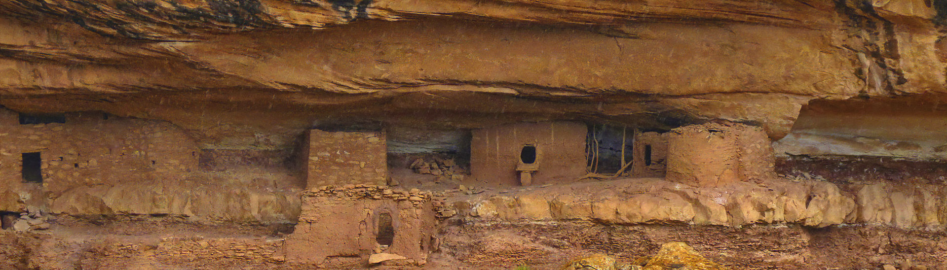
Bears Ears National Monument (SE Utah)
First visit (includes Natural Bridges National Park) (April 30, May 1-5, 2018; BobF Don, EdF & Joe)
Bryce Canyon NP (Utah), Zion NP (Utah), Coral Pink Sand Dunes SP (Utah), Kodachrome Basin SP (Utah), Pipe Spring NM (AZ) (3/5-8/2015; Don, BobF & Joe)
Yosemite Valley in Yosemite National Park, CA (8/9-11/2011; 2 hikes both about 5 miles
Wire Pass/Buckskin Gulch Trails (Utah) (10/11/2013; Don, Mike & Suzanne; 5 miles total
Washington State Hiking w/g-dau Audrey (Sep 21, 2017; Audrey & Don; 3 to 4 mile RT)